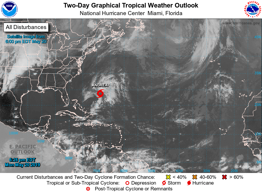
The first storm for the 2019 Atlantic hurricane season, Andrea, has formed north of the Caribbean.
The US National Hurricane Center said in an update on Monday evening that the sub-tropical storm currently poses no threat to land.

Details are as follows:
...SUBTROPICAL STORM ANDREA FORMS OVER THE WESTERN ATLANTIC...
SUMMARY OF 630 PM AST...2230 UTC...INFORMATION
----------------------------------------------
LOCATION...28.8N 68.7W
ABOUT 335 MI...540 KM SW OF BERMUDA
MAXIMUM SUSTAINED WINDS...40 MPH...65 KM/H
PRESENT MOVEMENT...N OR 350 DEGREES AT 14 MPH...22 KM/H
MINIMUM CENTRAL PRESSURE...1006 MB...29.71 INCHES
WATCHES AND WARNINGS
--------------------
There are no coastal watches or warnings in effect. Interests in
Bermuda should monitor the progress of this system.
DISCUSSION AND OUTLOOK
----------------------
At 630 PM AST (2230 UTC), the center of Subtropical Storm Andrea was located near latitude 28.8 North, longitude 68.7 West. The storm is moving toward the north near 14 mph (22 km/h).
A decrease in forward speed and a turn to the northeast is expected on Tuesday, followed by an eastward motion by Tuesday night. On the forecast track, the center of Andrea is expected to remain southwest or south of Bermuda during the next day or two.
Data from an Air Force Reserve Hurricane Hunter plane indicate that the maximum sustained winds are near 40 mph (65 km/h) with higher gusts. Slight strengthening is possible overnight. Weakening should begin late Tuesday, and Andrea is expected to dissipate on Wednesday.
Winds of 40 mph extend outward up to 70 miles (110 km) northeast of the center.
The Air Force Hurricane Hunters measured a minimum central pressure of 1006 mb (29.71 inches).
HAZARDS AFFECTING LAND
----------------------
None
NEXT ADVISORY
-------------
Next complete advisory at 1100 PM AST.

